 By Saurav Mehra
 A dense cluster of automobile dealerships along one road once earned Chennai an unexpected nickname: “The Detroit of India.” That reputation belongs largely to Thiru Vi Ka Salai — also called Thiru Vi Ka High Road or Thiru Vi Ka Street — one of the main arteries running through downtown Chennai, connecting three of the city’s most significant neighbourhoods along the way.
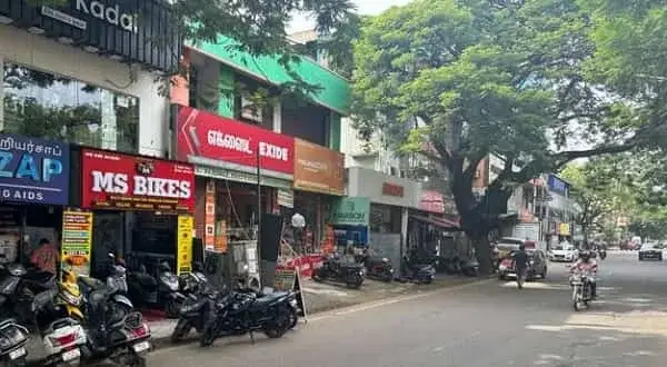
The Road That Made Chennai the “Detroit of India”
Thiru Vi Ka Salai runs north to south, branching off the arterial Anna Salai just north of the LIC Building and ending at Luz Corner in Mylapore, where it continues onward as Ramakrishna Mutt Road. Along its length, the road connects Royapettah, Mylapore, and Gopalapuram — three genuinely distinct neighbourhoods that together make up a substantial slice of central-south Chennai.
The road is actually a composite of three individually named stretches that have since been unified under one name: General Patters Road, Westcott Road, and Royapettah High Road. The longest of these, formerly Royapettah High Road, runs 1.17 km on its own. It was the concentration of automobile dealers on the northern end of this stretch that gave rise to Chennai’s nickname as “The Detroit of India” — a reputation the road has carried for decades and one that continues to shape its commercial identity today.
The road also carries a genuine piece of Chennai’s culinary and entertainment history: the original Woodlands Hotel once stood on Royapettah High Road, and its garden space is now occupied by a namesake cinema complex — a small but telling example of how this street’s landmarks have evolved generation to generation while retaining their names.
Thiru Vi Ka Street at a Glance
| Category | Details |
| Full name | Thiru Vi Ka Salai (Thiru Vi Ka High Road) |
| Location | Downtown Chennai, connecting Royapettah, Mylapore, Gopalapuram |
| Runs from | North of LIC Building (Anna Salai junction) |
| Ends at | Luz Corner, Mylapore (continues as Ramakrishna Mutt Road) |
| Former constituent names | General Patters Road, Westcott Road, Royapettah High Road |
| Longest stretch | Formerly Royapettah High Road — 1.17 km |
| Nickname earned by area | “The Detroit of India” (automobile dealers) |
| Nearest metro | LIC (Blue Line) — 3 min walk |
| Alternate metro | Thousand Lights (approx. 22 min walk, for southern stretch) |
| Nearest MRTS stations | Thirumayilai, Mundagakanniamman Koil (near southern end) |
| Under-construction metro | Royapettah (Purple Line), near Government Royapettah Hospital |
| Notable landmark | Original Woodlands Hotel site (now a cinema complex) |
| Connects at southern end | Kutchery Road, Luz Corner Junction |
| Notable flyover | Connects Royapettah and Mylapore |
Where Thiru Vi Ka Street Sits
Thiru Vi Ka Salai sits in the downtown region of Chennai, running through Royapettah, Mylapore, and Gopalapuram. Its northern end connects to Anna Salai near the LIC Building, while its southern end meets Kutchery Road at the Luz Corner Junction in Mylapore. A notable flyover along the road connects the Royapettah and Mylapore sections, and a busy five-road junction near the northern end of this flyover ties together Avvai Shanmugam Salai and Masilamani Street as well.
Getting to Thiru Vi Ka Street
LIC metro station, on the Blue Line, is the closest option for the northern stretch of the road, sitting just a three-minute walk away — genuinely convenient given how central this part of Chennai is. For the southern stretch near Mylapore, Thousand Lights metro station is the nearest option, though it’s a longer walk of around 22 minutes, so most visitors combine it with an auto or short cab ride.
Beyond the metro:
- MRTS/Rail: Thirumayilai railway station and Mundagakanniamman Koil railway station, both on the Chennai MRTS network, sit near the southern end of the road, useful for those approaching from that direction.
- Bus: Anand Theatre bus stop, close to the northern stretch, and AVM Rajeswari Kalyana Mandapam and Thiruvalluvar Statue stops near the southern stretch, all serve the road at different points.
- Upcoming metro: Royapettah metro station, on the under-construction Purple Line, will sit near Government Royapettah Hospital at the northern side of the road, promising to significantly improve connectivity once operational.
Given the road’s length and the fact that it runs through three distinct neighbourhoods, the best approach depends heavily on which stretch you’re heading to — checking whether you need the LIC or Thousand Lights end before setting out saves considerable walking time.
Shops and What the Street Is Known For
Automobile dealerships are Thiru Vi Ka Street’s most historically defining commercial feature, particularly concentrated on the northern end of the road. This density of car showrooms — spanning multiple brands over the decades — was significant enough to earn the wider Chennai area its “Detroit of India” nickname, a reputation that persists in how the city is sometimes described even today. TATA Motors is among the brands with a dealer presence in this stretch, reflecting the road’s continued relevance to the automotive trade.
Beyond automobiles, the road carries the everyday commercial texture typical of a major Chennai thoroughfare connecting several established neighbourhoods — office buildings, retail complexes like Sri Complex in Mylapore, and services catering to the residential populations of Royapettah, Mylapore, and Gopalapuram along its length. The presence of Government Royapettah Hospital near the road’s northern side adds a healthcare dimension to the area, while Kamarajar Arangam and other cultural venues sit within reach given the road’s central location.
Nearby Areas Worth Visiting Together
Royapettah, at the road’s northern stretch, is a well-established central Chennai neighbourhood with its own residential and commercial character.
Mylapore, at the southern end near Luz Corner, is one of Chennai’s oldest and most culturally significant neighbourhoods, home to the Kapaleeshwarar Temple and a rich temple-town atmosphere.
Gopalapuram, connected via the same road, extends the same central Chennai residential fabric a little further.
Luz Corner, where the road terminates, is a well-known landmark junction connecting Mylapore’s residential lanes to its main commercial and temple stretches.
FAQs
Q1. Why is Thiru Vi Ka Street associated with Chennai being called “The Detroit of India”?
The northern end of the road historically housed a dense concentration of automobile dealerships, a commercial identity significant enough that it contributed to Chennai’s broader nickname as India’s answer to Detroit, the American automotive manufacturing hub.
Q2. Which metro station should I use depending on which part of Thiru Vi Ka Street I need?
For the northern stretch near Royapettah, LIC metro station is closest at just a three-minute walk. For the southern stretch near Mylapore, Thousand Lights metro station is the nearest option, though it’s a longer 22-minute walk, so an auto for the last stretch is advisable.
Q3. Will connectivity to this road improve in the near future?
Yes — Royapettah metro station, currently under construction on the Purple Line, will sit near Government Royapettah Hospital at the road’s northern side, expected to significantly improve access once it opens.
Q4. Is Thiru Vi Ka Street the same as Royapettah High Road?
Royapettah High Road is one of three individual stretches — alongside General Patters Road and Westcott Road — that together make up the modern Thiru Vi Ka Salai. It was the longest of the three at 1.17 km and is often still referenced by its former name in older addresses and local usage.