 By Saurav Mehra
 Right next to Ranganathan Street, Chennai’s single busiest shopping stretch, sits Sarangapani Street — quieter, mostly residential-commercial, and doing a different job entirely. Where Ranganathan Street pulls in crowds for sarees and jewellery, Sarangapani Street runs on everyday essentials: readymade garments, stationery, general provision stores, and tailoring services serving the immediate T Nagar neighbourhood.
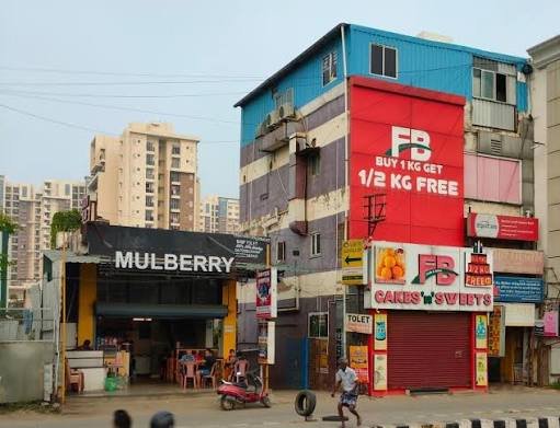
Where Sarangapani Street Sits
Sarangapani Street runs through the Rama Kamath Puram locality within T Nagar, officially Thyagaraya Nagar and historically known as East Mambalam. T Nagar itself is believed to be Chennai’s first planned urban neighbourhood, constructed in 1923–1925 by the Madras Presidency government under the Raja of Panagal, following the Madras Town Planning Act of 1920, and named after Sir Pitty Theagaraya Chetty. The neighbourhood is bordered by Nungambakkam to the north, Teynampet to the east, Nandanam to the southeast, and West Mambalam and Kodambakkam to the west. Sarangapani Street sits under Ward 117, within the Thousand Lights assembly constituency and Chennai Central Lok Sabha constituency, with pin code 600017 and NH32 running through the wider area.
Sarangapani Street Quick Info
| Category | Details |
| Location | Rama Kamath Puram, T Nagar, Chennai — 600017 |
| Ward | Ward 117 |
| Assembly constituency | Thousand Lights |
| Lok Sabha constituency | Chennai Central |
| National highway access | NH32 |
| Nearest metro | T Nagar metro station (Green Line) |
| Alternate metro | Nandanam, AG-DMS (Blue Line) |
| Nearby restaurants (within 1 km) | Barbeque Nation, Murugan Idli Shop |
| Best known for | Readymade garments, boutiques, general/provision stores, stationery, tailors |
| Boutique count (Justdial) | 224+ listed |
| General store count (Justdial) | 249+ listed |
| T Nagar founded | 1923–1925 |
| T Nagar neighbouring shopping hubs | Ramee Mall, Pothys Hyper, Super Saravana Stores, Maya’s Plaza |
Getting to Sarangapani Street
T Nagar metro station, on the Chennai Metro’s Green Line, sits right in the heart of T Nagar and is the most convenient way in, given how central it is to all of T Nagar’s shopping, dining, and entertainment. Nandanam and AG-DMS metro stations, both on the Blue Line, work as alternatives depending on which end of T Nagar you’re approaching from.
Beyond the metro:
- Rail: Mambalam railway station serves the wider T Nagar neighbourhood on the Chennai Suburban Railway network, a practical option for those arriving from other parts of the city.
- Bus: T Nagar’s dense MTC network, plus the Thiyagaraya Nagar Bus Depot near Panagal Park, connects the area to the rest of the city.
- Road: NH32 runs through the area, and major roads including Ranganathan Street, Usman Road, and NSC Bose Road all connect T Nagar to anywhere in Chennai by auto or taxi.
Parking can be genuinely tricky during peak shopping hours given how much traffic T Nagar draws — arriving by metro or auto and walking the final stretch to Sarangapani Street tends to be the smoother option, particularly on weekends.
Shops and What the Street Is Known For
Readymade garments and boutiques are a genuine strength on Sarangapani Street, with Justdial listing over 224 boutique businesses here, spanning designer boutiques, fashion boutiques, and bridal boutique options — a smaller-scale, more curated retail alternative to the sprawling showrooms found on nearby Ranganathan Street. General stores round out the practical side of the street, with nearly 250 listed provision stores, grocery shops, rice retailers, supermarkets, and dairy product retailers catering to daily household needs for T Nagar residents.
Stationery shops and tailoring services add further depth to the street’s everyday-essentials identity — practical businesses that keep the immediate neighbourhood self-sufficient without residents needing to travel to T Nagar’s bigger commercial stretches for routine needs. Food options are close by too: Barbeque Nation sits just 0.4 km away on Bazullah Road, and the well-known Murugan Idli Shop is a short 0.7 km walk on North Usman Road, both useful reference points for anyone spending a full day in this part of T Nagar.
The street’s proximity to Ranganathan Street means it benefits from the same relentless T Nagar foot traffic without carrying quite the same intensity — a genuinely useful stop for practical shopping needs sandwiched between some of Chennai’s most famous retail landmarks.
Nearby Areas Worth Visiting Together
Ranganathan Street, immediately adjacent, is T Nagar’s most famous shopping stretch — sarees, jewellery, and household goods across hundreds of shops.
Panagal Park, nearby, anchors the wider T Nagar area and hosts the main bus terminus for onward city travel.
Usman Road, a short walk away, is another of T Nagar’s major commercial roads, known for its concentration of textile and jewellery showrooms, including big names like Pothys and Tanishq.
Pondy Bazaar, close by, adds another dense pocket of T Nagar’s retail energy, along with restaurants and casual dining options for a break between shopping stops.
FAQs
Q1. Which metro station is closest to Sarangapani Street?
T Nagar metro station, on the Green Line, sits right in the heart of the neighbourhood and is the most convenient option, with Nandanam and AG-DMS on the Blue Line serving as alternatives.
Q2. What is Sarangapani Street known for?
Readymade garments and boutiques (over 220 listed), alongside general stores, stationery shops, and tailoring services catering to everyday shopping needs for T Nagar residents.
Q3. Is Sarangapani Street the same as Ranganathan Street?
No — they’re immediate neighbours within T Nagar, but Sarangapani Street is quieter and more residential-commercial, while Ranganathan Street is T Nagar’s flagship saree-and-jewellery shopping stretch.
Q4. Where can I eat near Sarangapani Street without walking too far?
Barbeque Nation is just 0.4 km away on Bazullah Road, and Murugan Idli Shop, a well-known Chennai breakfast institution, sits about 0.7 km away on North Usman Road — both easy walking distance from the street.